 Figure [1]. Forbidden City is the rectangular compound in the center of the picture. The lakes at the top left is where the Zhongnanhai Compound is located.
Republican Era (1911 - 1949)
The Power Vacuum and Gentry:
In 1911, the Qing Dynasty collapsed and a power vacuum existed in the larger region of China. Instead of an imperial government, China was partially ruled by a Nationalist government run by the Guomindang Party, and partially by a series of warlords who fought amongst each other to consolidate power and negotiate with the Nationalist government. From 1911 to 1928, Beijing changed hands between three warlords, until the Northern Expedition led by Chiang Kai-shek finally consolidated the Guomindang’s power over the capital city. Because of the warlords’ tendency to focus on more important power struggles, and because of the Nationalist government’s disdain for the northern city, Beijing in this era was largely left to its devices, relying on the local gentry to stimulate urban policy. Transportation policy is a great example of how the city shifted its focus from dynastic service to incorporating the public in its planning. This decentralization also manifested itself in the city’s design, as the city center devolved from the imperial Forbidden City to various centers with different purposes.
One characteristic of the pre-industrial Chinese city was the presence of local gentry. These gentry were basically people who could afford to have free time to spend at public spaces, such as teahouses, brothels, and opera houses. It was at these public spaces in which wealthy landowners and local movers and shakers met to discuss various topics. They would also talk about issues related to the city. For example, the gentry would complain about poor electricity, lack of water, tax increases, food shortages, and more [1]. Essentially, these people made up the potential for a local-run city government without any legal basis to actually become a self-governing society. It was from this unofficial think tank that urban policies came about. Most of these policies came from private, commercial investments that had ripple effects across urban society. For example, it was these men who invested in rickshaw companies that became iconic to Beijing. The rickshaw provided a way for lower class citizens to earn money. Then, as a ripple effect, a police force was created in response to passenger-driver conflicts that required a mediator to step in. This police force was mostly made up of the Manchurian soldiers who were out of a job once the Qing Dynasty fell [2].
The Deformed Center:
As the central government shifted the focus away from Beijing as a municipal center, the focus on development moved to incorporate the wider public into decision-making. Beijing as a city started to institute policies that benefitted the people who lived there, rather than the emperor and his court. One enormous example of this was the fact that the Nationalist Municipal Council began to tear down walls in order to create more roads. Otherwise, pedestrian and rickshaw traffic would bottleneck at the gates in the walls [3]. Roads were also extended on north-south and east-west axes for improved capacity and expansion of the city. One major symbol of this is Qian Gate, which was built to literally stop traffic, but eventually modified to allow traffic to flow through [4]. Furthermore, an increase in variety of modes of transportation allowed pedestrians many options to get around Beijing quicker. In Beijing during the Republican era, there were 15 train stations, 15 taxi stands, 19 rickshaw shops, 21 horse-pulled cart companies, 24 bike rental shops, and even an airport [5].
The first warlord to rule Beijing after the fall of the Qing, Zhang Zuolin, preferred to live amongst the lush gardens of Zhongnanhai, a man-made lake just east of the Forbidden City [6]. Moving the power base from the middle of Beijing, Forbidden City, to just slightly off kilter Zhongnanhai was a symbol for the decentralized urban policies of Beijing at the time. When the Emperor still held power, the Forbidden City was the center of all activity in Beijing. However, the move to Zhongnanhai also meant that there was a shift in where the city’s center was focused. Instead, Beijing had multiple centers. In fact, Strand mentions that “the empty, unformed, or deformed center is a defining characteristic of the Republican era” [7]. He identifies four new centers in Beijing. Students hung out in the northeast corner of the Inner City, where universities were clustered, foreigners lived and worked in the Legation Quarter, just southeast of the Forbidden City, ministries and other bureaus surrounding Zhongnanhai struggled along in the face of an impending capital shift, and the main business center laid in Dazhalan, in the north edge of the Tartar City [8].
 Figure [2]. Beihai Park, the second former imperial garden to be turned into a park.
Transformation from an Imperial Space to a Public Park:
A major example of the shift in urban planning policies and how they involved the public is how the Municipal Council exerted its power to stimulate public interest in transforming a Qing imperial garden into a public park. Toward the end of the Qing Dynasty, reformers desperately attempted to encourage the imperial government to select a space to open to the general public. This concept was inspired by reformers who went abroad and saw parks for the people in cities like Paris, London, and even Tokyo. However, this idea would not come to fruition until 1914, when the Republican-run Municipal Council started promoting the idea of a public park. They printed a Municipal Gazette that stated the benefits of parks, like increased exercise and health, recreation, and reduced crime. The language of the Gazette was aimed toward the wealthy elite, who then used their networks and word of mouth in order to stimulate interest in the project.
When the Municipal Council finally garnered enough interest in developing a park, they began to lie out plans and exploration committees. Their main problem was that Beijing was overdeveloped – there was simply a lack of open space. Secondly, the Council itself lacked money, as the Republican government invested more money and more time in placating the warlords of the north (including Zhang Zuolin, who lived in and controlled Beijing at the time). Transforming an imperial garden into a public park made the most sense. In crowded Beijing, these former gardens were already built, and came with walls and gates, and other park-like amenities, like benches, lawns, bridges, and so on. To raise money, the Council created a Central Park Administration. They offered membership on the board for a large fee. The response was successful. The Administration raised enough money to run the park, and decisions were made by voting. On October 10, 1914, Central Park was opened to the public, and was the first public park in Beijing [9].
 Figure [3]. Chang'an Avenue Expansion.
Communist Era (1949 - current)
The Beijing Municipal Institute of City Planning & Design (BICP)-The General Plan:
During the rising era of Communism in the early 1950s, the BICP proposed several urban plans, such as the Twin City Plan in 1949, the focus on satellite town Revised Master Plan in 1957, the New Version of the Master Plan with attention to historic preservation and housing infrastructure in 1983, the New 20 year plan proposed in 1993, and lastly the 2004-2020 New Master Plan with a focus on new towns. Architects Liang Sicheng and Chen Zhanxiang, who both desired to make Beijing the political and cultural center while preserving the historical nation, proposed the Twin City Plan (similar to the planning of Washington D.C. as the political center with an emphasis on a multi-nucleus urban model) in 1949 [10]. They wanted to build new urban centers around the city, thus connecting the new structures to the old. However, Soviet professionals like M.G. Barannikov and S.A. Boldyrev wanted to dismantle the old Beijing and develop it into an industrial setting [11]. They believed that the old Beijing needed some revival in its economic planning since there were hardly any industries and that it should no longer represent a city that serves aristocrats. Mao Zedong, the Communist Party leader at the time, was impressed with the Soviets’ vision of the new Beijing and overpowered the plan Liang and Chen had in mind. The plan called for the industry development in the suburban areas and large-scale housing and city construction [12].
In the early 1950s, many of the new buildings were located near the suburbs while the governmental infrastructures and factories were scattered around. From 1957 to 1958, the BICP brought forth a few revisions that included large-scale industries be moved from urban spaces to the far suburbs in addition to new satellite towns surrounding the city center [13]. It was designated the main layout of the city called the “Scatter-Conglomeration” since satellite towns are surrounding the urban center of Beijing [14]. It was supposed to be function as protection of the city environment and to be used for city development later on.
During the Cultural Revolution in the mid-1960s that focused on the conflict between Mao Zedong and other political leaders for the power of the Communist Party, the Beijing master plan lost its importance but was reinstated in 1972. In 1973, the planning department resumed to put together the Overall Planning Scheme; meanwhile, the committee would review the plans and coordinate the constructions. During this time, the historical city was already changed since the walls of the Imperial City were torn down for the rising factories along with road infrastructure [15]. The master plan in 1982 placed strong emphasis on carrying out economic development while adhering to the city nature and its resources. It also limited the city population to about 11.4 million people and promoted satellite town building to manage the overcrowding issue (24 satellite towns taking up 104 square kilometers can hold up to 920,000 people) [16]. To prevent more pollution, this plan also stopped the opening of new industries and prohibited any dismantlement of the courtyard housing to protect housing infrastructure.
Furthermore, the New 20 year plan proposed in 1993 was to make the existing industrial city of Beijing into an international modern society. The plan also sought to improve its infrastructure, urban roads, as well as the protection of the green spaces by reducing the number of polluting factories. Urban expansion should be under control and population growth should be directed towards the satellite towns, which are supposed to hold many residents. Last, but not least, the 2004-2020 plan urged to fix problems concerning the city development like rapid population expansion and urban sprawl. Its main strategy is to take a step back and consider metropolitan regions for developing new towns as part of the urban center. The new towns are supposedly upgraded versions of the satellite towns and proposed to have different functions- industries, parks, medical center, etc. There is also a plan to reinforce the existing urban centers and promote new ones, one on the west and east side. While protecting the cultural and historic areas going through development, the plan also yearned to preserve the northern and western sides of the mountain (fixing environmental problem) and to develop the areas near the east (resolving economic problem) [17].
Focus on the East-West Axis in the 1950, The Chang’an Avenue:
The North-South axis (known as the “Dragon Vein”) in the old Beijing before the year 1912 symbolized imperial power that excluded the common people. The 7500 meter long of walls and gates including the Inner City, Outer City, the Imperial City, Palace City, and the Forbidden City contributed to the inconvenience to the public since it blocked communications between the east and west sides of Beijing [18]. The development of the Chang’an Avenue construction in 1949 broke the imperial character of the old Beijing and opened the east-west axis. It now stretches from the eastern Tongxian County to the western Shijingshan District. Furthermore, the Chang’an Avenue also had its political influence when the former center of power located in the Forbidden City was shifted to the Zhongnanhai republican government in the western side of Beijing [19].
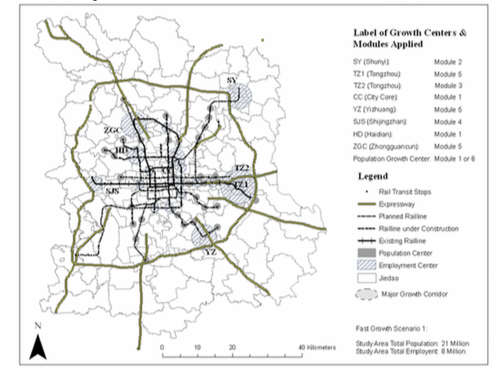 Figure [4]. Compact Growth.
Expanded Section on the 2004-2020 Plan with Three Scenarios [20]:
Scenario 1: Compact Growth
- Aim towards growth in the major transit centers like Tongzhou, YiZhuang, Haidian, and Shijingshan
- Promote job-housing balance to prevent lengthy commute time, traffic jams, and decreased employee efficiency
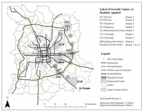 Figure [5]. Eastward-Directed Expansion.
Scenario 2: Eastward-Directed Expansion
- Conduct growth to the Shunyi, Tongzhou, and Yizhuang satellite towns (eastern regions)
- Prevent further development in the western and northern regions (environmentally sensitive because of mountains)
- Balance out the residents and employment in the eastern region
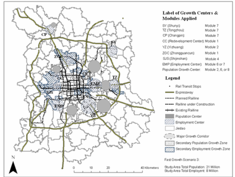 Figure [6]. Outward Expansion.
Scenario 3: Outward Expansion
- Development in all directions reaching out from the center point
- Balance between housing and industrial infrastructure
Sources:
[1] David Strand, Rickshaw Beijing (University of California Press, Ltd: 1989), 168.
[2] Strand, Rickshaw Beijing, 65.
[3] Madeline Yue Dong, Republican Beijing: The City and Its Histories (University of California Press, 2003), page 34.
[4] Dong, Republican Beijing, 36.
[5] Dong, Republican Beijing, 34.
[6] Strand, Rickshaw Beijing, 27.
[7] Strand, Rickshaw Beijing, 17.
[8] Strand, Rickshaw Beijing, 27.
[9] Mingzheng Shi. "From Imperial Gardens to Public Parks," Modern China 24 (1998): 219-254.
[10] Jing Zhou, The Urban Project: Architectural Intervention in Urban Areas, https://books.google.com/books?id=i6SKP1ss_ckC&pg=PA392&dq=beijing+twin+city+plan&hl=en&sa=X&ved=0CCcQ6AEwAGoVChMI37fhxZ_NxwIVQyyICh0dkQuk#v=onepage&q=beijing%20twin%20city%20plan&f=false p. 392-393
[11] Chang-tai Hung, Mao’s New World: Political Culture in the Early People’s Republic https://books.google.com/books?id=MH_R2jbwNuEC&pg=PA275&dq=beijing+soviet+architects&hl=en&sa=X&ved=0CDkQ6AEwBWoVChMI_82ImarNxwIVEpmICh0-OQ3Z#v=onepage&q=S.A%20Bol&f=false p. 31
[12] Christy Ivie, Razing Shantytowns and Raising New Villages: Urban Housing in the People’s Republic of China 1949-56 p. 108
[13] Jing Zhou, The Urban Project: Architectural Intervention in Urban Areas, https://books.google.com/books?id=i6SKP1ss_ckC&pg=PA392&dq=beijing+twin+city+plan&hl=en&sa=X&ved=0CCcQ6AEwAGoVChMI37fhxZ_NxwIVQyyICh0dkQuk#v=onepage&q=beijing%20twin%20city%20plan&f=false p. 392-393
[14] Beijing Municipal Institute of City Planning & Design (BICP), http://www.bjghy.com/ghyEng/ghyEng1profile.aspx
[15] Jing Zhou, The Urban Project: Architectural Intervention in Urban Areas, https://books.google.com/books?id=i6SKP1ss_ckC&pg=PA392&dq=beijing+twin+city+plan&hl=en&sa=X&ved=0CCcQ6AEwAGoVChMI37fhxZ_NxwIVQyyICh0dkQuk#v=onepage&q=beijing%20twin%20city%20plan&f=false p. 392-393
[16] Chengri Ding, Yan Song and Gerrit Knaap, “Growth Scenarios for Beijing 2020: Technical Report on the Beijing’s 2020 Comprehensive Plan Revision Process. 2005. P. 11
[17] Chengri Ding, Yan Song and Gerrit Knaap, “Growth Scenarios for Beijing 2020: Technical Report on the Beijing’s 2020 Comprehensive Plan Revision Process. 2005. https://www.lincolninst.edu/pubs/dl/1074_Ding_complete_web.pdf
[18] ShuiShan Yu, “Redefining the Axis of Beijing: Revolution and Nostalgia in the Planning of the PRC Capital” p. 574
[19] ShuiShan Yu, “Redefining the Axis of Beijing: Revolution and Nostalgia in the Planning of the PRC Capital” p. 576
[20] Chengri Ding, Yan Song and Gerrit Knaap, “Growth Scenarios for Beijing 2020: Technical Report on the Beijing’s 2020 Comprehensive Plan Revision Process. 2005. P. 27-30
Media:
[1] Forbidden City and Zhongnanhai Compound [Web Photo]. Retrieved from http://beihai-park.com/introduction-for-beihai-park/
[2] Beihai Park [Web Photo]. Retrieved from http://beihai-park.com/introduction-for-beihai-park/
[3] The forming of the east-west axis of Beijing in the 1950s from “Redefining the Axis of Beijing: Revolution and Nostalgia in the Planning of the PRC Capital” p. 572
[4] Growth Scenarios for Beijing 2020, https://www.lincolninst.edu/pubs/dl/1074_Ding_complete_web.pdf p. 28-30
[5] Growth Scenarios for Beijing 2020, https://www.lincolninst.edu/pubs/dl/1074_Ding_complete_web.pdf p. 28-30
[6] Growth Scenarios for Beijing 2020, https://www.lincolninst.edu/pubs/dl/1074_Ding_complete_web.pdf p. 28-30
