 Figure [1]. Layout of the Dadu City (Beijing). The Imperial Palace is protected by 3 layers of wall barriers from intruders outside the main city walls.
Yuan Dynasty (1271-1368)
Establishment of Dadu City (Beijing):
Beijing was established in its present location near Taiyechi, or Supreme Lake, in the Yuan Dynasty (1271-1368) and was formerly known as Dadu City, ruled by the Mongol leader Kublai Khan. Khan commissioned a Han scholar, Liu Bingzhong, who studied ancient cities and city construction to layout plans for a new capital city near the lake, which comprised of a north lake and south lake [1]. Building of the new city along with its canal systems began in 1267 and took 18 years to accomplish. The city of about 50 square kilometers greatly resembled the guidelines from the Kao Gong Ji, known as the Book of Artificers, however some modifications were made to meet the visions of the emperor [2].
The emperor’s palace, the most important location in the city, was aligned to a north-south axis just east of the southern Taiyechi lake. The Imperial Palace has four walls constructed around it giving rise to what we know today as the “Forbidden City.” The emperor’s mother, known as the empress dowager, and the crown prince each have a palace west of the southern lake. A bridge and islands on the south lake were built for accessibility and recreational purposes linking the two sides of the lake. The three palaces including the south lake were enclosed by four walls creating the Royal City [1].
The rest of the capital city was enclosed by four large walls that included the north part of the Taiyechi lake and contained major streets running north-south and east-west, following the traditional grid-field system [3]. The southern wall of the Royal City was reconstructed to include a direct road from the Imperial Palace to a south wall gate as depicted in a “T” shape in Figure 2. A main canal system was built to bring water from the north lake around the east wall of the Royal City, eventually connecting to the pre-existing Jin Dynasty water system south of the city. This system provided water for small towns and villages outside the city walls. Although the city plans followed the Book of Artificers, changes were made to meet the emperor’s vision of the city including 1) the city not forming a square but instead a rectangle 2) The Imperial Palace is not located in the geometric center of the city, but rather south of it and 3) instead of 3 gates on each outer city wall totaling 12 gates, the north wall only has 2 with the total of 11 gates [1].
In 1285, the city was completed and the magnificent imperial city that the emperor envisioned became a reality through much time and long labor, and 800 years later, it is still one of the world’s most influential cities known for its rich culture, long history, and flourishing economy.
 Figure [2]. The city of Beijing in Ming Dynasty.
Ming Dynasty (1368 - 1644)
From Dadu City to Beijing City:
After Yuan dynasty collapsed in 1368, Ming established their capital city at Nanjing at first, but it moved after. After Zhu Di won the battle with other Ming’s royal members, he became the third emperor, The Yongle Emperor, of Ming dynasty. He was the one making changes for the Beijing city since he renamed Dadu as Beijing in 1402 and made many construction programs to prepare Beijing become as a new capital from 1403. He moved the capital city to Beijing in 1421 after the city construction completed [3]. Ming has reconstructed the city walls by moving the northern wall about 2.5km south and 1km south of the southern wall and rebuilt the new emperor’s palace: the Forbidden City [1]. This Forbidden City was completed in 1421, and it was located at center of Beijing which also symbolized his centrality. All these construction constituted the new city layout of Beijing in the Ming Dynasty.
The indentation of north city wall and expansion of south city wall changed the Beijing city layout greatly. The construction of south defensive wall added a part to the previous imperial city, which is the Outer city. These changes shaped the city layout of Beijing in Ming Dynasty and the whole imperial city into a combination of two rectangles. The rebuilt Inner City wall was 22km long and new constructed Outer City wall was 14km long. There are nine gates along the Inner City wall and seven gates along the Outer City wall. The Imperial City position in the south center of Inner City and the wall was 9km long. The Imperial City was the place for royal members resided until the decline of Qing dynasty [4].
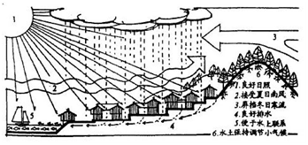 Figure [3]. The good ecological effect of Fengshui Theory.
The city site selection is the first prerequisite when considering building a town or a capital city, and Fengshui Theory is the guidelines in selection the location. Under the Ming dynasty, the Forbidden City was built to the south in accordance with city axis, and it was symmetrical. This symmetrical design formed a typical Fengshui pattern and played a significant role in creation of microclimate for the Forbidden City. Fengshui Theory is an ancient Chinese Urban planning theory addressing city site selection, and this history of urban planning of Beijing’s imperial city is the example bringing theory into practice [4].
The transformation into Beijing city under Ming dynasty was consisted of four enclosures:
Qing Dynasty (1644-1912)
Continued Development of the City:
The Qing Dynasty also established its capital in Beijing, but it did not make major changes to the city layout [1]. The city remained at the same site and the Forbidden City was still a palace for royal members. Most of the old palaces, buildings and monuments from Ming dynasty were repaired and reused, but they also erected some palace buildings in the Forbidden City and the imperial park. The Qing emperors also construct many palatial gardens around Beijing as their recreation places, but they were destroyed by the British invaders in 1860 and allied armies of eight nations in 1900 [4]. The Beijing physical configuration in the Qing Dynasty that remains today deeply influence the planning and city development of modern Beijing.
The transformation into Beijing city under Ming dynasty was consisted of four enclosures:
- The Palace City (the Forbidden City)
- The Imperial City
- The Inner City
- The Outer City
Qing Dynasty (1644-1912)
Continued Development of the City:
The Qing Dynasty also established its capital in Beijing, but it did not make major changes to the city layout [1]. The city remained at the same site and the Forbidden City was still a palace for royal members. Most of the old palaces, buildings and monuments from Ming dynasty were repaired and reused, but they also erected some palace buildings in the Forbidden City and the imperial park. The Qing emperors also construct many palatial gardens around Beijing as their recreation places, but they were destroyed by the British invaders in 1860 and allied armies of eight nations in 1900 [4]. The Beijing physical configuration in the Qing Dynasty that remains today deeply influence the planning and city development of modern Beijing.
Sources:
[1] Renzi Hou, The Transformation of the Old City of Beijing, China---A Concrete Manifestation of New China's Cultural Reconstruction, 2014, Pg 31-48
[2] Jun Wang, Beijing Record: A Physical and Political History of Planning Modern Beijing, 2011, Pg 45-50
[3] Stephen Marshall, Urban Coding and Planning, Chapter 6 Prescribing the Ideal City: Building Codes and Planning Principles in Beijing by Qinghua Guo, 2011, Pg 110
[4] Hao, Li. The Implications of the Planning of Beijing's Imperial City for Sustainable Community Development,2013, Pg 3-8, 19-21
Media:
Figure [1]: Michael Conzon, World Patterns of Modern Urban Change—Essays in Honor of Chauncy D. Harris, Chapter 2: Transformation of the Old City of Beijing China, 1986, Pg 37
Figure [2]: Hao, Li. The Implications of the Planning of Beijing's Imperial City for Sustainable Community Development, 2013, Pg 7
Figure [3]: Hao, Li. The Implications of the Planning of Beijing's Imperial City for Sustainable Community Development, 2013, Pg 40
